


Seceda - Boucle à partir du sommet du Téléphérique

Damien1271
User
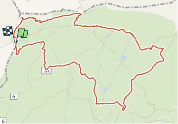

Length
7.3 km

Max alt
2509 m

Uphill gradient
416 m
Km-Effort
12.8 km

Min alt
2108 m

Downhill gradient
412 m
Boucle
Yes
Creation date :
2025-06-10 10:20:54.19
Updated on :
2025-06-12 08:01:41.027
2h54
Difficulty : Difficult

FREE GPS app for hiking
 SityTrail
IGN / Geographical institutes
SityTrail Plus
The world is yours!
About
Trail Walking of 7.3 km to be discovered at Trentino-Alto Adige/Südtirol, South Tyrol, Santa Cristina Gherdëina - St. Christina in Gröden - Santa Cristina Valgardena. This trail is proposed by Damien1271.
Description
Attention, gros dénivelé pour le retour vers le téléphérique qui ferme à 17h30
Positioning
Country:
Italy
Region :
Trentino-Alto Adige/Südtirol
Department/Province :
South Tyrol
Municipality :
Santa Cristina Gherdëina - St. Christina in Gröden - Santa Cristina Valgardena
Location:
Unknown
Start:(Dec)
Start:(UTM)
708677 ; 5164055 (32T) N.
Comments